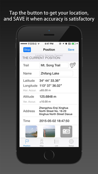
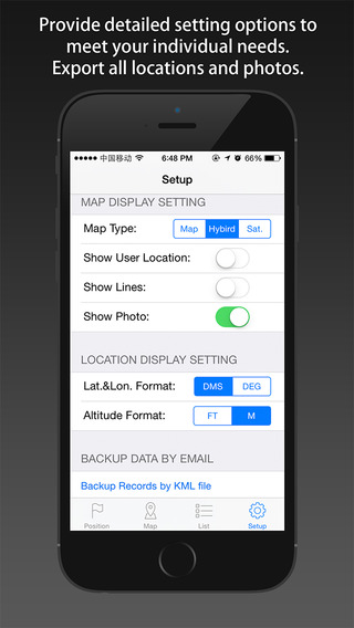
This is almost the most green location record tool in the App Store. This App is very easy to be used recording the location. In the process of marching, you can record the current position of longitude, latitude, altitude, address, and photos. All of data can be derived, including photos, and can be opened in the post-processing software such as Google Earth. The Location information is under the WGS84 coordinate system, its accuracy depends on the phone acquisition and positioning environment. [capabilities] 1. The use of mobile phone GPS sensors, acquire and save the current position of longitude, latitude, altitude and address information. 2. Support the save point on a editor, you can add a photo for each position. 3. Display the saved location on the map. 4. Statistics all the location of the elevation change information, to draw the chart way into the picture. 5. No purchase, no background, no advertising. [save electricity design]1. Don't record track, only record the location of the interesting point. 2. The positioning function whether open is completely determined by the user, provide switch button for operation, and use it every time you open the can. 3. The software automatically shut down into the background positioning function, shut down the background refresh function. 4. In both positioning function and display on the map function, optimization software made possible, make the minimum power consumption and the network flow. 5. Only in case of necessity, guiding users to use network traffic (on the left an anchor point too far, or unable to get WIFI around fingerprint). [data export] 1. According to CVS list file format export position. 2. KML format can be derived position list file, the file can be opened by Google Earth software. 3. Can export all the position of the corresponding photos. [usage scenarios for example] (1) each group of students to use a mobile phone, install the software, in the process of marching, marching to a certain point, the open software to record the longitude and latitude and elevation of point, photograph and to identify the points and the surrounding scene. Return after meeting place, the teacher open the software, check each group of students records and travel route, will be exported to each group of students travel information, and clear the records of every phone. Use Google Earth shows on the computer and evaluation. (2) the boss (wife, girlfriend) to arrange the employee (husband, boyfriend) to specify the location to complete the specified tasks, request to open the software records after location, photographic record working site, and added to the current location information. Check the work location and site information after return. (3) is suitable for measuring staff, measure the position of the poles, measure the position of the CMC, measure the position of the camera,... , one by one to collect coordinates and take photos. Returns derived measurement data, using CAD software to open the coordinates, log files, exhibition points on topographic maps. (4) in the process of travel, because of other software is very power, use the software only meaningful one location, and location information to arrange the photos. We would like to open the record, no running in the background, save electricity, convenient. Pics can also returned to the camp, once more.


免費玩LocRec APP玩免費
免費玩LocRec App
LocRec APP LOGO

LocRec APP QRCode
| 熱門國家 | 系統支援 | 版本 | 費用 | APP評分 | 上架日期 | 更新日期 |
|---|---|---|---|---|---|---|
| 未知 | iOS App Store | 2.1 App下載 | $2.99 | 2014-09-07 | 2015-06-04 |