CFI Tools Area Weather - AreaWx
-----------------------------------
PURPOSE: The Area Weather App is used by a pilot to view METARs and TAFs plotted on a color-coded map or in a simple text table or in raw format. The weather is displayed for all METAR stations within the specified area.
>>>> Please Note <<<<<
This App is no longer available as a stand-alone App
It has been moved to the General Aviation App.
Find it here: https://play.google.com/store/apps/details?id=com.edgemontsystems.generalaviationa
>>>>>>>>>>>>>>>>>>> <<<<<<<<<<<<<<<<<
The area is defined by a METAR station and a radius around the station.
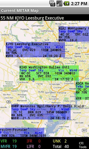
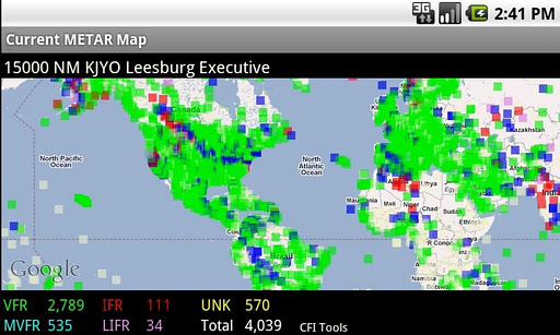
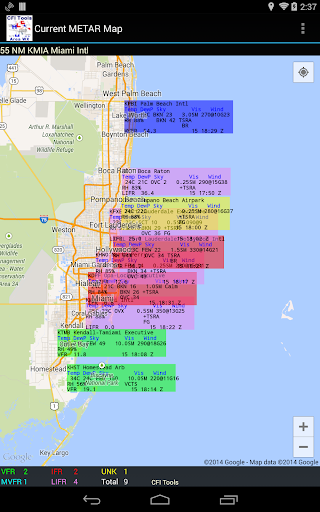
METARs on a Map
-----------------
The METAR data is displayed for the pilot on a map that adjusts based on the size of the area. The METARs are colored coded based on the aviation flight category (VFR, MVFR, IFR, LIFR) for the station. The color coding and placement on the map gives a good quick overview of the current weather in the area.
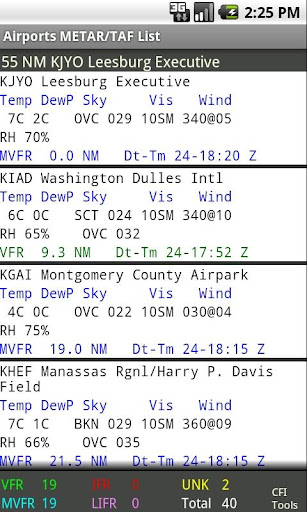
METARs in a Table
-------------------
The METAR data may also be displayed in a table that allows more detailed viewing for stations in the area.
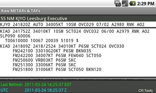
The stations are sorted based on their distance from the base station. Tap any station in the table to see the complete raw data for the METAR and if available TAF.
How it works
-------------
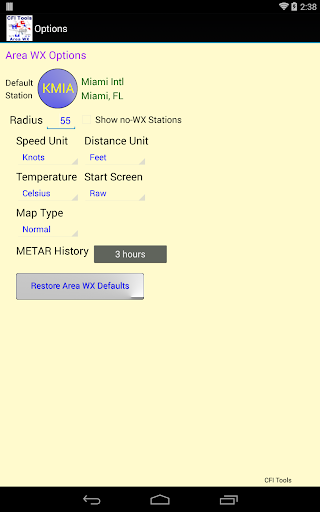
Touch the Menu button to define the Area.
The Area is defined by entering the ICAO identifier for the station. There is a fast search function that allows search by ID, airport name or city. After a station is chosen simply enter the radius preference.
An internet connection is required to get the METAR data.
Preferences
----------------
You can have the App start-up on either the Map screen, the Stations screen or the Raw data screen.
Measurement units for Wind speed, Temperature and Distance can be set on the Options Screen.
Airports in the Database
--------------------------
PLEASE NOTE: The source of the METARs used in this App is the NOAA National Weather Service Aviation Weather Center. It can be found here:
http://aviationweather.gov/adds/metars/
If the METAR station can not be found on this site, it will not be in the App.
The database used in the App contains over 10,000 worldwide airports.

Please Note
-------------
This App has been thoroughly tested with METAR information from around the world. However I want to emphasize the need to verify this data.
One thing that you may not realize is that METAR data may be entered by hand. That means that it is possible that there could be typos or simply some added information that is not expected by the software. This added information could cause unpredictable results and the user should be alert to this possibility.
----------------
About CFI Tools
----------------
I'm a Pilot and a CFII. I build these Apps and other software for my own use.
The Apps have been for sale now for a number of years. They have been enhanced and updated based on listening to the suggestions of the pilots who use them.
Any suggestions for improvement or new apps are always welcomed.
Have a good flight.
免費玩CFI Tools Area WX APP玩免費
免費玩CFI Tools Area WX App
CFI Tools Area WX APP LOGO
CFI Tools Area WX APP QRCode
| 熱門國家 | 系統支援 | 版本 | 費用 | APP評分 | 上架日期 | 更新日期 |
|---|---|---|---|---|---|---|
| 未知 | Android Google Play | 1.17 App下載 | USD$4.99 | 1970-01-01 | 2015-03-11 |