Which Way (WW) is a simple decision aid that helps to answer the question "What's the fastest way to get from here to there?"
I use Google Maps to monitor real-time traffic every day when I commute, but there are 2 things that I find it does not do:
1. I cannot specify the exact route I intend to take to and from work. Google Maps is very good at telling me how drive to new places. I'm better at finding the best way to and from work every day.
2. Google Maps does not inform me that while traffic is flowing on my route right now, it will be backed up at the choke point when I reach it in 20 minutes.
WW is designed to bridge these gaps.
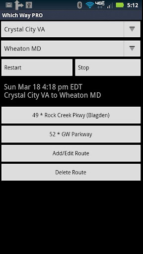
Each route is defined by an origin, destination and route. For example: "Wheaton MD", "Crystal City VA", "GW Parkway".
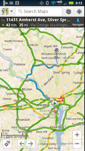
You can then attach a web link created on the PC version of Google Maps to check real-time traffic on each of your routes.
Additionally, WW has a trip recorder. By recording your actual commuting time, you enable WW to predict which of your routes is typically fastest as a function of when you start you commute. You can then use the web link to check for unusual real-time traffic delays.
To record trip data:
1. Start Which Way before you begin your commute.
If Which Way is already running, press Restart.
At this point Which Way will display a button for each defined route. The buttons are in order of increasing commute time and each button displays the estimated time of commute (based on *your* historic commuting data) before the name of the route.
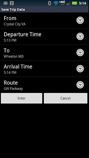
2. Press Stop when you reach your destination to bring up the data recording screen. Edit the values as necessary (new origins, destinations and routes can be added to the defaults by selecting "new") and press enter.
It's that simple!
Notes:
0. This is the free trial version of Which Way. It is identical to Which Way PRO except that it is limited to 6 total routes (not including the examples) and about 6 months of trip recording.
1. WW ships with my commuting data from Wheaton MD to Crystal City VA that I've been recording for > 2 years.
2. This app was previously known as Which Way DC.
3. Wouldn't it be great if the prediction was based on historic travel time *and* current traffic conditions? I'm working on it...
4. Sometimes there are issues with the way that the Google Maps link opens on the phone vs. the way it appears on a PC web page. This question has been asked on Google's Maps Forum (https://groups.google.com/a/googleproductforums.com/forum/#!category-topic/maps/issues-and-troubleshooting/maps/mobile-android/mobile-app/YMwpPBNnNlU) but not yet answered. If anyone has a workaround (or any other suggestions), please email me (I can't reply to comments).
5. You can attach any valid web link to the button -- it doesn't need to be Google Maps. Again, I'd be interested in what web links people find useful -- please email.
免費玩Which Way FREE APP玩免費
免費玩Which Way FREE App
Which Way FREE APP LOGO

Which Way FREE APP QRCode
| 熱門國家 | 系統支援 | 版本 | 費用 | APP評分 | 上架日期 | 更新日期 |
|---|---|---|---|---|---|---|
| 未知 | Android Google Play | 3.4 App下載 | 免費 | 1970-01-01 | 2015-04-25 |